Friday, January 29, 2016

Data Shows Decrease in Driver's License Numbers

If Superbad was shot today, McLovin would be having
his adventures on the bus
We've been saying for the past few years that fewer people are driving (although the overall miles
driven has actually increased) and that young people are deciding not to drive in record numbers. How do we know that? Drivers license data.

According to the Human Transit blog, University of Michigan researchers recently released an update on the percentage of people with driver’s licenses in the United States. In 2011, data showed that the percentage of young people with driver’s licenses decreased noticeably between 1983 and 2008.
The percentages for 20- to 24-year-olds fell from 91.8% in 1983 to 82% according to the 2011 research. The updated numbers show that those percentages fell again, to 76.7% in 2014.

So how are these young people getting around if not driving? Uber and Lyft show promising numbers but their data doesn't show that's the main way millennials are getting from point A to point B. According to statistics from transit agencies, it's by public transit. 

Thursday, January 28, 2016

Input Wanted On Proposed Millwood Trail


Apparently, a lot of people are interested in a potential new trail for the area, because a public meeting at Millwood City Hall for the Millwood Trail last night had an impressive turnout of enthusiastic people, at least while I was there.

When complete, the trail will traverse three area jurisdictions on former railroad right-of-way- Spokane Valley, Millwood and the City of Spokane. The portion that will cross through Millwood (the agency that hosted the meeting last night, along with a consultant hired to manage Millwood's portion of the trail) starts at Vista Road, continues across Argonne Road and past the city park and Avista substation to the Trent Avenue overpass.
When connected with sections in other jurisdicitons, the trail will connect Spokane Community College at Green St and continue east of to approximately Woodruff Road and Trent in Spokane Valley.

At the meeting last night, a team working on the project asked people what amenities they would like to see on the trail. Some of the most popular items were lighting, trash cans, restrooms, landscaping and vegetation, and educational signage.

If you have thoughts on this project but didn't make the meeting, you can still submit comments or talk to project staff. More information on the Millwood Trail and contact information is here.

Planning and design of the trail is underway right now and is expected to continue through June of 2016. Currently construction of the trail is planned for 2017 and 2018 although the phase of the project has no dedicated funding source at this time.

Wednesday, January 27, 2016

Scope Changes Will Improve Projects for Citizens

Something kind of cool happened in the Transportation Technical Committee (TTC) meeting today. One of the items on the agenda was "Scope Change Requests." Staff from the City of Spokane and Spokane Valley were requesting to change the description of planned projects that are being paid for with federal funds provided through SRTC. To be in compliance, requested changes have to be run through SRTC for approval if they wish to change the scope significantly.

Two projects really stood out because they would provide significant improvements over what is currently planned. The first project was the Downtown Spokane Bicycle Network. It had two phases and was essentially finished in 2015. However, in looking back at the first phase, City staff was concerned that they had pretty much done the minimum on that project, basically just painting some bike lanes and calling it good. Their scope change request was to go back and improve upon that by adding sharrows or other markings to the roadway and signs as well. These improvements won't cost any additional money than is already dedicated to the project as the project came in under budget.

The second project, in Spokane Valley, is for Mission Avenue near the intersection with Long Road. The original plan was to make the section in question three lanes, with one lane each direction and a center turn lane. It would also have sidewalks and bike lanes. After meeting with people who live in the neighborhood several times, Valley staff decided to change the project description after realizing that's not what residents want. Instead, they are seeking to eliminate the third lane and just make the roadway two lanes. The extra space from the third lane will instead (if approved by the SRTC Board) be used for the bike lanes on each side and separated sidewalks. Plus they requested a roundabout at the intersection with Long Road in order to slow traffic down. This change also will not require any additional funding.

What is exciting about this is that it shows how public involvement is working and that staff at area jurisdictions really do care. The City could have walked away from their bike network project realizing it wasn't as good as it could be and said "good enough." But they didn't. And Spokane Valley staff could have politely thanked citizens for their input and carried on with the project as planned. But they didn't.

So here is the next step: members of the TTC voted today to recommend to SRTC's Board that they accept these scope changes. The Board will vote in February on whether to move ahead with them.

Forget a Real Pony, A Pony Cycle Could Be More Fun

Bikes are fun and a good workout and all but why ride a boring old bike when you can ride a pony? Ponycycle, that is. New Zealand has a new transportation option with Ponycycles, a ride-on mechanical gizmos for both children and adults.

The "toys" have a wheel at the end of each leg and moved forward through human power by pumping your legs, kind of like swinging. Right now a company is only renting them out in New Zealand but they plan to sell them for home use soon. They are also available in South Africa.

The best part- these ponies don't need food, water or grooming.

Why Go to the Gas Station When You Can Have the Fuel Delivered to Your Car?

Are you so busy that you don't even have time to put gas in your car yourself? A new app could help. Or it could make us the laziest people on the planet. According to The Verge, WeFuel is basically like ordering anything else you need- parts for the refrigerator, clothes, you can even have groceries delivered these days.

To use it, you download the app, type in the location of your car and request a fuel delivery. Within about 30 minutes, a hazmat-certified driver arrives in a truck and fills your vehicle with gas. If your gas tank door doesn't require a key, you don't even have to be there.

The cost per gallon for the gas is calculated daily based on specific zip codes but where the company makes it's money is from the $7.49 fill up fee. There are plans later to start a monthly scubscription service for unlimited fills at $19.99 per month per car, plus the price of the gas.

While WeFuel is only operating in the Silicon Valley currently, there are several other gas delivery apps that have sprung up lately, including Filld, GasNinjas, FuelMe and Yoshi. 

Tuesday, January 26, 2016

2015 Record Year For Vehicle Miles Traveled

A couple years ago, everyone in transportation was reporting that driving was down. People were finding other ways to get around- riding their bikes, the bus, whatever. Then we heard that people were getting back behind the wheel. And today there is news from the U.S. Department of Transportation, on their Fast Lane blog, that 2015 was a record year for vehicle miles traveled. 

According to USDOT numbers, U.S. drivers ran up almost three trillion (yes with a 't') vehicle miles traveled last year. Each of the first 11 months of 2015 showed an increase of between 2.5 and 4.9 percent from the same month in 2014. Data isn't in from December yet. Even so, those numbers make 2015 the most heavily traveled year in history.

That doesn't necessarily mean that individuals are driving more miles. The population has grown, meaning more people are driving, and truck shipments have increased, putting more large trucks on the road.

This isn't a record that those of us in the transportation industry are celebrating. Each of those miles means a lot of wear and tear on our roadways, increases greenhouse gas emissions, and increases traffic congestion.


DOE Hosting Workshops on Oil Train Shipments

If you are interested in shaping laws related to oil shipments through Washington State, the Department of Ecology is holding a couple workshops for the public at its' Spokane office.

The Spokesman-Review reports that the first workshop will focus on contingency planning for oil-by-rail shipments. It is from 8:30-11:30 a.m. tomorrow, Wednesday, January 27.

The second workshop, also tomorrow from 1:30-4:30 p.m., will address notification requirements of oil shipments by rail and pipeline, including how much information to release to the public.

The Department of Ecology’s Spokane office is at 4601 North Monroe Street.You can find more information at http://www.ecy.wa.gov/programs/spills/rules/1513ov.html.

Monday, January 25, 2016

Transportation Technical Committee Meeting This Week

The first Transportation Technical Committee (TTC) meeting of 2016 is this Wednesday, Jan. 27. The meeting agenda can be found here.  TTC meetings are always open to the public so if something on the agenda catches your interest, feel free to attend. They start at 1:30 p.m. in the SRTC conference room at the Intermodal Center, 221 W. 1st Ave., Suite 310. 

All-Community Central City Line Workshop Scheduled

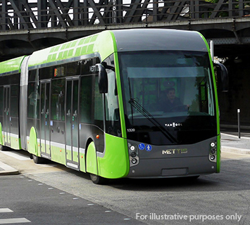
CCL Vehicle Type
Mark your calendars- Spokane Transit is hosting an All-Community Central City Line Workshop to update citizens on the project and gather input on a variety its elements including:
  •  Alignment (which roads through Downtown it will travel on)
  • Stop locations
  • Station design and amenities
  • Potential land use policies and economic development incentives to complement the project’s transit function

The workshop is Tuesday, February 2 in the lobby of the Pharmaceutical & Biomedical Science (PBS) Building at WSU Spokane from 4-6 p.m.

Area Centennial Trail Priorities Set for 2016

The Friends of the Centennial Trail Board each January sets priorirites for the year for the trail. Here are the priorities they recently determined for 2016:
  • Finalize a gap completion plan for Argonne Road.
  • Find a solution for the Trail gap from Boone to Pettet Drive that provides Class 1 roadway separation.
  • Invest in way finding signs, markers and mile posts when it is expedient to do so.
  • Support Spokane City Parks plan to renovate the Don Kardong Bridge.
  • Encourage Trail use counting technology in the Spokane Valley and Riverside State Park.
  • Advocate for all recreational trails in the region.
  • Support completion of six major Trail maintenance projects in 2016.

Wednesday, January 20, 2016

Amendment Proposed to Transportation Improvement Program

An amendment to the 2016-2019 Transportation Improvement Program (TIP) proposes adding a Spokane Valley project to the program and increasing the total cost of a Washington State Department of Transportation (WSDOT) project.
The TIP is a document that identifies projects programmed to be undertaken or constructed during the upcoming four years. It includes project names and descriptions, the jurisdiction sponsoring them, funding attached to each project, and where the funding came from (local, state or federal funds). The TIP is updated regularly throughout the year as SRTC’s member jurisdictions have projects to add, change or remove from the program.

The amendment under consideration would:

·     Add a Spokane Valley project to the program that will reconstruct the asphalt pavement of the Sullivan/Euclid intersection and approaches with cement concrete, rehabilitate and/or replace stormwater facilities and upgrade curb ramps to ADA standards. It will also improve the geometrics of the west leg of the intersection.
·     Increase the cost of a project already in the 2016-2019 TIP from $400,000 to $550,000. This WSDOT project would install fiber optic communications and Closed Circuit TV cameras on US 2 from Spotted Road to I-90.

Details on the proposed amendment are below. Do you think the amendment is a responsible way to spend tax payer dollars? A public comment period for the amendment starts Wednesday, January 20, 2016. Members of the public are encouraged to provide input. All comments must be received by 4 p.m. on Friday, January 29, 2016. Comments can be submitted by emailing to contact.srtc@srtc.org, mailing to SRTC at 221 W. 1st Ave., Suite 310, Spokane, WA, or by calling (509) 343-6370.


Construction Starts on Phase 2 of MLK Way In May

Construction on phase 2 of Martin Luther King Jr. Way starts in May, according to the Spokesman-Review. The project will stretch from Sherman Avenue (where the University District bicycle and pedestrian bridge will eventually be located) to Erie Street, near Brown Building Materials. The project is expected to cost $2 million.

The first phase of the project, basically an extension of Riverside Avenue, opened in 2012 and cost $3.8 million. When complete, the entire street will run from Division to a roundabout at the intersection of Trent and Perry. So far, there is no firm date for completion.

, but city officials said there is not yet a firm completion date. When this year’s phase is complete, it will add a new connection between downtown Spokane and the East Central neighborhood, passing through the heart of the University District.

In anticipation of the extension, the city spent $410,000 last year to pave Erie Street from First Avenue to the future MLK Way.

Aside from the anticipated construction of the bike-pedestrian bridge spanning the railroad tracks, the city will pave and extend the Ben Burr Trail that connects Liberty and Underhill parks. The $1.2 million project will begin in April. The multiuse path will start at the south side of Underhill Park, go underneath Interstate 90 and Sprague Avenue, and follow Erie to the river’s edge, where it will run west to meet with the Centennial Trail.

Tuesday, January 19, 2016

Transportation Advisory Committee Meeting January 25

The first meeting of the Transportation Advisory Committee (TAC) in 2016 is next Monday, January 25 here at SRTC. The TAC is a citizens' committee that advises the SRTC Board on policy topics and provides transparency to the transportation planning process.

The agenda for the next meeting is here. TAC meetings are open to the public and all are welcome so feel free to attend if you are interested. Meetings start at 3 p.m. at 221 W. First Ave., Suite 310.

Best Way To Get Rid Of A Giant Rock Blocking the Highway? Blow It Up

How do you get rid of a 20-ton boulder blocking an important stretch of highway? Caltrans blew it up. A landslide in the Sierra Nevada blocked the westbound lane of U.S. 50 blocking the highway between Sacramento and Lake Tahoe.

Crews drilled holes in the 18 foot rock and placed explosives in them and then the fun started. You can see for yourself below.

Higher Fines Proposed for Left Lane Campers

I know several of you who will love this. Driving slow in the fast lane could get more expensive in Washington under a proposal that would impose penalties for “aggravated left-lane driving” with new fines based on how slow they are going.

According to the Spokesman-Review, the proposed Senate bill says driving slow in the left passing lane of a multilane road can create safety hazards and cause other drivers to brake unexpectedly or create traffic congestion.

The state already has a traffic law against driving too slowly and blocking traffic in the passing lane. The fine for that is $136. Washington State Patrol officials said troopers made about 14,000 of these stops in 2015.

The proposed law would add another fine for continuously driving at slow speeds, based on how far below the speed limit someone is driving.

Between 1 and 5 mph, the extra fine would be $27. That would go up to $37 for 6 to 10 mph below the maximum speed limit; $52 for 11 to 15 mph and $67 for 16 to 20 mph.

The Senate Transportation Committee could vote on whether to send the proposal to the full Senate in the coming weeks.

Monday, January 18, 2016

Millwood Trail Project Public Meeting

The City of Millwood has begun the planning and design phase of the proposed Millwood Trail project, a bike and pedestrian trail located on the former Great Norther Railroad right of way between Vista Road and the Trent Avenue overpass.

The city will host a public meeting Wednesday, Jan. 27 from 4-6 p.m. at Millwood City Hall, 9103 E. Frederick Ave., to teach members of the public about the project, answer questions and receive input.

You can find more information on this project, and the meeting, here.


Spokane City Traffic Calming Workshops

The City of Spokane's Office of Neighborhood Services is offering upcoming Traffic Calming Workshops for each City Council District. The workshops will provide a one-on-one opportunity for neighborhoods to speak with an engineer and go over example project applications.

Come learn what traffic calming is and what opportunities your neighborhood has for these projects and bring ideas if you have them. For more information, go to www.spokaneneighborhoods.org/programs.

District One:
January 26th, 5:30-7:00pm
Northeast Community Center
4001 N. Cook St., Lower Level

District Two:
January 27th, 5:30-7:00pm
Southside Senior & Community Center
3151 E. 27th Ave., Schultz Room

District Three:
February 3rd, 5:30-7:00pm
West Central Community Center
1603 N. Belt St., Mason Room

Friday, January 15, 2016

Proposed Oil Terminal Brings Many Out for Hearing

A hearing on a crude oil terminal in Vancouver, Washington brought out over 100 people to a hearing in Spokane Valley last night, many of whom oppose it.

The Spokesman-Review reports that opponents who signed up to speak at the hearing, held by Washington's Energy Facility Site Evaluation Council, said such a facility would  put Spokane and other communities at risk from increased oil train traffic, without offering any local economic benefits.

Four additional trains carrying oil would travel through the area per day if the terminal is built.

Sandpoint and Missoula residents also spoke out, saying the extra trains puts their cities at higher risk for derailment and spills too. Longer wait times at rail road crossings was also a concern for many.
However, the project received support from local carpenters and boilermakers who said an oil-consuming nation like the U.S. requires a reliable supply of oil. A representative of one are carpenters union said oil trains are safer than using a pipeline and more efficient than trucking it in.

A BNSF spokesman said that oil trains travel at lower speeds through populated areas, about 20 to 35 miles per hour in our area,

Missouri State Rep Wants Cyclists to Ride with 15 Foot Tall Flags

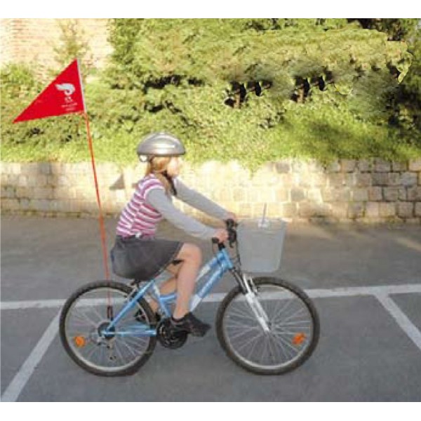
Take this flag and triple the length and
still wouldn't be as long as this guy
is asking for.
Remember that bike with the sweet banana seat and flag you used to have as a kid? A lightweight flag that was- what?- maybe four or five feet tall at the most?

Well a Missouri State Rep wants people to ride with the adult equivalent of that flag- a 15 foot tall pole with an orange flag at the top. Yes, 15 feet!

Citylab says State Representative Jay Houghton (R) is pushing a bill that would require cyclists to carry these rods for "safety" reasons, although who's safety isn't specified.
Seems to me this pole could cause some safety issues of it's own: throwing off a rider's balance and catching low-hanging branches, bridges and wires. If you're wondering if maybe Mr. Houghton has something against cyclists, he did co-sponsor a bill in 2013 that would prohibit riders from using state roads when there is state-owned bicycle path or trail that runs generally parallel to and within two miles of the thoroughfare. Luckily it didn't pass.

Thursday, January 14, 2016

Traffic Signals Will No Longer Blink at Several Locations

The City of Spokane will no longer set traffic signals to flash during early morning hours at several intersections citywide. Programmed flash will be eliminated at these intersections beginning Monday, Jan. 18, according to a news release just sent out:

·         Addison at Francis
·         Addison at Wellesley
·         Alberta at Wellesley
·         Ash at Broadway
·         Belt at Wellesley
·         Bernard at 29th
·         Broadway at Jefferson
·         Buckeye at Post
·         Crestline at Euclid and North  Foothills
·         Crestline at Empire
·         Crestline at Wellesley
·         14th at Grand
·         Grand at 29th
·         Hawthorne at Nevada
·         Holland at Nevada
·         Illinois at Perry
·         Jay at Nevada
·         Lincoln at Nevada
·         Lyons at Nevada
·         Magnesium at Nevada
·         Market at Queen
·         Mission at Napa
·         MLK at Pine
·         North Foothills at Perry
·         Pittsburgh at Wellesley
·         Ray at 17th
·         Ray at 29th
·         Regal at 37th
·         Regal at 29th
·         SE Blvd at 29th

Vehicle detection systems were recently installed at each intersection, so programmed flash is no longer needed to facilitate traffic flows. Vehicle detection allows the signals to respond promptly to vehicle demand. The system will allow for more efficient service during low volumes times when programmed flash was previously used (1 a.m. to 5 a.m. weekdays and 2 a.m. to 5 a.m. on weekends). 


Eliminating programmed flash also provides for 24/7 operation of pedestrian signals at those intersections. Pedestrian signals do not work during programmed flash.

About SRTC

SRTC is the federally designated Metropolitan Planning Organization (MPO) for Spokane County. Urbanized areas with populations exceeding 50,000 people are required to have an MPO. SRTC was formed to address the county's transportation planning needs. It provides coordination in planning between the public, cities, small towns, the county, the state, transit providers, and tribes.

SRTC offers services including transportation monitoring, transportation modeling, census information analysis, travel demand forecasting, historical traffic count analysis, geographic information systems, and trip generation rates.