Monday, Oct. 10 is Indigenous People's Day (formerly Columbus Day) in the City of Spokane, so parking meters don't have to be plugged. Local governments will remain open however, including SRTC and Spokane City offices.
Friday, October 7, 2016


Thursday, October 6, 2016
Seattle Metro Asking To Rent Parking Spaces For Commuters

rail rather than driving their own cars.
Participating building owners and property managers need to offer at least 20 spaces attached to multi-family or mixed-use residential developments to be eligible for the program. Parking spaces must also have safe pedestrian connections within a quarter-mile of a frequent transit service. King County Metro will market the program, and Diamond Parking will manage the logistics.
A survey by Metro found that daily park-and-ride users said they would be willing to pay about $44 to $110 per month for a guaranteed parking space near their transit stop.
Seattle has the fifth-worst traffic in the country, and during evening commute hours nearly three-fourths of roads are congested. Yet half of Seattle residents still drive to work. Metro is hoping making more parking available near transit will change that by motivating more people to use public transit.
The parking pilot program will begin early next year.
Jukeboxes May Soon Help You Get A Ride Home

Well, I was excited to find out that you may be able to find a ride home using the jukebox. TransitScreen, a global information company, has partnered with TouchTunes Media and Pernod Ricard USA, a spirits and wine company, to add a real-time, local transit display feature to TouchTunes Digital Jukeboxes in over 200 locations around the United States.
TransitScreen appears in the jukebox’s video loop and shows real-time information about nearby trains, subways, buses and taxis as well as ride-hailing options such as Uber or Lyft. Patrons can also select the information directly.
In some cases, liquor brands such as Jameson, Absolut and Malibu, are even sponsoring the TouchTunes Media local transit information program.
So far, Spokane jukeboxes don't have this option but TransitScreen officials say all 10,000 bars within the TouchTunes network will have TransitScreen functionality in the foreseeable future.
Wednesday, October 5, 2016
How Revolutionary Personal Transit Idea Take Off?
 |
| West Viriginia's Personal Rapid Transit cars. |
Even so, West Virginia University, which runs the PRT system, isn't giving up on it and is spending more than $100 million to refurbish the aging system. With PRT, riders start from a central station downtown and pay 50 cents each (free if you are a student) to get in a small car that only goes to your destination and doesn't stop anywhere else.
Each car holds about 18 people and a sign over the cars indicates where they are headed. PRT's advantage is that, unlike traditional transit, the car doesn't stop at multiple stops as it heads to it's final destination. Another advantage is that if there's a midday lull, and the cars aren't needed, they just sit at a station and wait, rather than running empty.
The system provides 15,000 rides on a typical day (Morgantown has a population of 30,000) — and doubles that ridership when there's a home football game.
Sounds great right? So why hasn't PRT caught on? For several reasons; opposition from companies that make systems for buses and light rail, questions about the reliability of the new technology, and uncertainty about PRT's cost-effectiveness.
Tuesday, October 4, 2016
City Contracts With Uber Rather Than Build A Parking Garage
 |
| Summit, New Jersey |
According to BuzzFeedNews, the move was initiated to avoid building a new parking lot for the station. Parking near Summit’s train station has been called a "nightmare" by many users. Commuters buy parking permits, but are not assigned spaces, and often waste 15 to 20 minutes searching for a spot. Building a new parking lot for commuter users would be a long-term, multimillion-dollar endeavor, so the city's administrator instead decided to subsidize commuters’ Uber rides to the town’s train station. Priced at $2 each way, the rides will cost commuters the same as an all-day parking pass. Not only will this reduce demand for hard-to-come-by parking spaces, it will also create a steady pool of demand for Uber.
Uber was interested and agreed to a six-month pilot program. Over the long run, if the program becomes permanent, it is expected to cost Summit only about $167,000 annually, much less than the $10 million it would cost to build a parking lot, which doesn't even count costs to staff and maintain it.
Monday, October 3, 2016
Local Road Construction Update
 WSDOT
WSDOTUS 2/Spotted Road to I-90 Intelligent Transportation Systems- Fiber optic cable installation. Possible shoulder and/or lane restrictions during night work through Sept. 30. Day work beginning Oct. 3 with no traffic impacts expected.
SR 290/Maintenance shoulder work- Maintenance crews will be working on guideposts and shoulder on the eastbound side from around 9 a.m. until as late as 3:30 p.m., Tuesday through Thursday, Oct. 4-6. No traffic impacts are expected.
SR 291- vicinity of Big Sandy Hill/Maintenance drainage Work- Maintenance crews will be working on storm water drainage facilities from around 9 a.m. until as late as 3:30 p.m., Monday through Thursday, Oct. 3-6. Some lane restriction with possible delays.
US 395-NSC/Freya & Wellesley Intersection Roundabout- The Wellesley/Freya intersection is closed to traffic. A signed detour is in place. Planned completion is late Monday, Oct. 10.
SPOKANE VALLEY
44th from Locust to Ponderosa- Reduced to a two lane gravel roadway with speeds reduced to 15 mph through October 7.
44th from Schafer Branch to Ponderosa- Reduced to one lane from 7 a.m. to 5:30 p.m. weekdays through October 7.
Appleway from Park to Dishman-Mica- Reduced to two lanes through the end of October for street improvement work with sidewalk, lane, and temporary side street closures. Local access and access to businesses is available.
McDonald from Sprague to Mission- Closed to all but local traffic every day until Wednesday, October 12. Signs detour traffic via Pines or Evergreen. Sidewalk closures with signs to mark pedestrian detour routes.
Sullivan Road Bridge Replacement Project- Northbound traffic is reduced to one lane with vehicles restricted to ten feet wide or less. Oversized vehicles should use Barker or Pines as alternatives. Turns from Indiana onto northbound Sullivan are reduced to one lane. One southbound lane is closed at Flora Pit Rd during working hours Monday to Friday. Expect nighttime signal work Tuesday, October 4, 8:00 p.m. to midnight at Sullivan/Indiana with flaggers directing traffic.
SPOKANE COUNTY
Seven
Mile Bridge & Seven Mile Road- Bridge
approach work and road work tie-ins. Watch for loose gravel. A bypass road is in place with a temporary speed limit of 25 mph.
Hawthorne
Road West (Waikiki to US395)- Completion
of road, stormwater reconstruction, signal improvement, bike lane, and striping. The road is open with temporary lane restrictions for cleanup work.
Hawthorne
Road East (US 395
to US 2)- Road
reconstruction, stormwater upgrades, curb, signal, bike, and striping. The road is open to traffic but there are some lane restrictions for cleanup work.
Argonne
Road (Spokane
River to Wellesley)- Road
reconstruction, stormwater retrofit, paving. Argonne is reduced to one lane in each direction. Expect long
delays. Right turns only at Maringo Dr. (no cross traffic
movements).
Upriver Drive intersection and Argonne Road Intersection- Closed Wednesday, October 5th. A detour will be in
place.
Country
Homes (Wall
to SR 395)- Stormwater
work in the raised islands.Traffic is one lane in each direction on the North side of the
islands, side road access to and from Country Homes is restricted, expect
delays.
Missile Base Road (Town of Rockford)- Road is closed to traffic. Paving of the roadway is scheduled for Wednesday, Oct. 5.
Centennial Trail- Improvement of the trail, tree root removal,
pavement removal and replacement, repair concrete, crack sealing. Portions of the trail may be closed to pedestrian traffic.
SPOKANE CITY
1st Avenue Et Al, Erie to Helena- Water Main installation work is ongoing. Street surface grinding begins Monday, October 3 on 1st Avenue from the intersection of Helena to Perry. Local access will be maintained. Work will begin in 1st Avenue and Helena Monday, October 3. The intersection of Helena will be closed for this paving. Traffic will be detoured to Perry and Napa.
37th Avenue, Regal Street to Custer Street- 37th Avenue from Freya to Custer Street is closed. 37th is also closed at Havana Street. The detour route is Glenrose to Palouse Highway to Regal Street. Crews are currently grading from Freya to Myrtle. This work is to reconstruct the road, include pavement replacement, curbs, sidewalk, bike lanes, stormwater piping, and a 36 inch water main.
Ben Burr Trail and Connection to the Centennial Trail- Crews are installing new storm crossing and new ADA ramps on 2nd Avenue, closing the street from Napa to Arthur Street. Lane restrictions are in pace on 2nd Avenue between Altamont and Napa. The freeway on ramp remains open and exit 282B has been reduced to one lane. Third Avenue has lane restrictions from Arthur to Altamont Street. The crossing at Perry Street under the I-90 freeway is closed. Crews are installing new ADA ramp in these locations.
SPOKANE CITY
1st Avenue Et Al, Erie to Helena- Water Main installation work is ongoing. Street surface grinding begins Monday, October 3 on 1st Avenue from the intersection of Helena to Perry. Local access will be maintained. Work will begin in 1st Avenue and Helena Monday, October 3. The intersection of Helena will be closed for this paving. Traffic will be detoured to Perry and Napa.
37th Avenue, Regal Street to Custer Street- 37th Avenue from Freya to Custer Street is closed. 37th is also closed at Havana Street. The detour route is Glenrose to Palouse Highway to Regal Street. Crews are currently grading from Freya to Myrtle. This work is to reconstruct the road, include pavement replacement, curbs, sidewalk, bike lanes, stormwater piping, and a 36 inch water main.
Ben Burr Trail and Connection to the Centennial Trail- Crews are installing new storm crossing and new ADA ramps on 2nd Avenue, closing the street from Napa to Arthur Street. Lane restrictions are in pace on 2nd Avenue between Altamont and Napa. The freeway on ramp remains open and exit 282B has been reduced to one lane. Third Avenue has lane restrictions from Arthur to Altamont Street. The crossing at Perry Street under the I-90 freeway is closed. Crews are installing new ADA ramp in these locations.
This project
will construct a paved trail connection from the Centennial Trail
at the Gonzaga Bridge southeast of Erie Street and continuing to Liberty Park
where a connection will be made to the existing Ben Burr Trail. The trail will then continue on the existing
Ben Burr Trail to the trailhead immediately south of Underhill Park.
Bridge Avenue and Monroe Street CSO Work- Work
continues on pouring of the concrete floor slab. Summit
Blvd./Bridge Ave. is closed to traffic. Lincoln has
one northbound lane open. Lincoln
southbound is closed at Broadway. This project
will construct a Combined Sewer Overflow Tank (CSO) tank and piping for our Cleaner River Faster Program.
Hazels Creek Stormwater Treatment Project- Work continues on Freya south of 37th Avenue on a stormwater treatment system with disposal ponds and stormwater piping. This system will be an extension of the existing Hazel’s Creek Facility on 42nd Avenue.
Indiana Avenue from Dakota to Perry Street- Remaining work includes pouring curb supports, landscaping, installing electrical, installing signs, pavement markings throughout the project, a swale repair and one swale instillation. The next paving date is Tuesday, October 18. The project is on track to finish by Monday, October 31.
Martin Luther King Jr. Way Phase 2A Sherman to Erie Street- Rock
excavation is in progress. Phase 2A is an extension of Martin Luther King Jr. Way from Sherman to
Erie Street. This is a continuation of the Riverside Extension Phase 1 project. This project will provide traffic a route that eliminates several safety issues and
increases capacity into and out of the downtown area while passing along the
south edge of the University District. These improvements include a new asphalt
pavement street, utility infrastructure, storm drainage improvements, street
lighting, street trees, and re-vegetation with native species. In lieu of
sidewalks, the project will construct a section of the Ben Burr trail to
provide pedestrian circulation.
Monroe/Lincoln Street Couple, 8th Avenue to 2nd Avenue- Construction crews will be working on top lift paving the week of October 8. Striping and cleanup will follow. This project reconstructs the roadway from 8th to 2nd Avenue and installs storm water and water facilities. The portion of this project that reconstructed the street from 2nd to 4th Avenues is substantially complete.
Pettet Drive/TJ Meenach Combined Sewer Overflow Project- Pettet Drive is closed to traffic. The intersection of Pettet Drive and Nora Avenue is scheduled for paving on Monday, October 3.
This project will build a 690,000 gallon storage facility and
connections to existing CSO Basin 10 outfall.
Work also includes repaving of Pettet Drive and pedestrian/bike trail
construction.
Wall Street, Main Avenue to Spokane Falls Boulevard- Sidewalk and curb installation is completing. Paving will be Tuesday, October 4 and Wednesday, October 5. Wall Street will be substantially complete Thursday, October 6. Wall Street from Main to Spokane Falls is closed. Work has started at Main and Wall heading north toward Spokane Falls. This work is to construct storm water improvements, sidewalks, new asphalt pavement, traffic signal revisions, an irrigation system, and add lighting.
Keep Leaves Out of Storm Drains
 |
| Leaves can clog drains, causing this kind of mess. |
drains. The City of Spokane Valley is asking for your help to keep leaves out of storm drains.
When too many leaves get into the drains, they can cause standing water that damages roadways, creates a driving
hazard, and may flood adjacent properties. Wet leaves can also make sidewalks
and roadways slippery for pedestrians and vehicles.
You can help by keeping leaves and debris from your yard out of the street, off the public sidewalk, and away from storm drains. Here are some tips from the City of Spokane Valley Stormwater Division to manage all those leaves and make your lawn and garden healthier:
- Raking
frequently helps your grass get needed sunlight and oxygen.
- Bag up those leaves and take them to the
Spokane Valley University Road Transfer Station at 2405 N. University
Road.Find information and disposal rates at www.spokanevalley.org/solidwaste by selecting the "Yard Waste/Organics"
link, or by calling 509-924-5678.
- Another option is to mow over dry leaves
using a mulching blade on your mower and leave them in place to provide
nutrients for your lawn.
- Pile leaves on bare areas in vegetable
gardens and flower beds, or around the base of trees.Spray with a little
water to help generate topsoil that can absorb more water next year and
reduce watering needs.
- Lean how easy it is to turn leaves and
debris into organic compost that can provide nutrients for healthier
trees, lawns and gardens.Find more information on composting, as well as
opportunities for training to become a Master Composter, at www.spokanecounty.org/2024/Master-Composter-Program. There are a limited number of training openings
available to Spokane Valley residents so be sure and visit the website
soon.
Centennial Trail Work Starts Next Monday
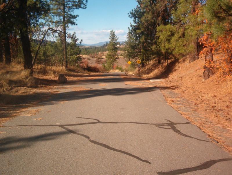 |
| One section of the Centennial Trail, near the Military Cemetery trailhead, that needs asphalt removed and replaced. |
Crews will work east to west, starting at the Idaho state line and finishing up in Nine Mile Falls. Work will continue through November but is weather dependent.
More information on the work is on the Spokane County Public Works website at http://www.spokanecounty.org/257/Public-Works.
 |
|
|
Thursday, September 29, 2016
Last Chance to Comment on the draft Transportation Improvement Program
 Last chance to give us your thoughts on the draft 2017-2020 Transportation Improvement Program (TIP). The public comment period ends this Sunday, Oct. 2.
The TIP lists transportation projects and programs to be built or implemented during the upcoming four years. All projects receiving federal funds are required to be included in the TIP. It is updated with new projects annually and includes project names and descriptions, jurisdictions sponsoring them, funding attached to each project, and where the funding came from (local, state or federal). The 2017-2020 TIP contains:
- One hundred and twenty projects, with 24 projects new to the TIP this year (a table of the new projects is below);
- A total of $563.4 million in local transportation investments to be spent between 2017 and 2020.
The 2017-2020 TIP can be viewed at http://www.srtc.org/tip.html. There is also an interactive map at that page that shows how the projects are distributed throughout Spokane County.
Comments can be emailed to contact.srtc@srtc.org, mailed to SRTC at the address below, or phoned in to (509) 343-6370.
Table 2. New Projects in the 2017-2020 TIP
Agency
|
Project Name
|
TIP ID
|
Page
|
Spokane
|
Sprague Ave at Sherman St. Pedestrian Plaza
|
SP051
|
X
|
Spokane County
|
Harvard Road
|
CO043
|
X
|
Spokane County
|
Bigelow Gulch/Forker Road Connector Project #6
|
CO044
|
X
|
WSDOT
|
Eastern Region BST Rumble Strips E - Install Rumble Strip
|
WS099
|
X
|
WSDOT
|
Eastern Region Guardrail Installation and Retrofit 2021-23
|
WS100
|
X
|
WSDOT
|
Eastern Region Safety Improvements - Install Rumble Strip
|
WS101
|
X
|
WSDOT
|
I-90/Geiger I/C to Latah Creek - Illumination Rebuild
|
WS102
|
X
|
WSDOT
|
I-90/Lincoln Co Line to Geiger Rd - Roadside Safety Improvements
|
WS103
|
X
|
WSDOT
|
US 2/Fairchild AFB - Signal Replacement
|
WS104
|
X
|
WSDOT
|
US 2/Garfield Rd - Signal Rehabilitation
|
WS105
|
X
|
WSDOT
|
US 2/Lawson Rd - Signal Rehabilitation
|
WS106
|
X
|
WSDOT
|
US 395/NSC Columbia to Freya
|
WS107
|
X
|
WSDOT
|
US 395/NSC Spokane River Crossing
|
WS109
|
X
|
WSDOT
|
US 395/NSC Spokane River to Wellesley
|
WS110
|
X
|
WSDOT
|
US 395/NSC Sprague Ave to Spokane River
|
WS111
|
X
|
WSDOT
|
US 395/NSC Wellesley to Columbia
|
WS112
|
X
|
WSDOT
|
2021-23 ER Region Wide Basic Safety - Signing
|
WS113
|
X
|
WSDOT
|
2021-23 ER Region Wide Safety - Guardrail
|
WS114
|
X
|
WSDOT
|
I-90/Barker Rd Intersection Improvements
|
WS115
|
X
|
WSDOT
|
I-90/ER Illumination Rehab Phase 2 - Retrofit Luminaires
|
WS116
|
X
|
WSDOT
|
US 2/ER Illumination Rehab Phase 2 - Retrofit Luminaires
|
WS117
|
X
|
WSDOT
|
US 395/Deer Park Corridor Safety Improvements
|
WS118
|
X
|
WSDOT
|
US 395/Illumination Rehab Phase 2 - Retrofit Luminaires
|
WS119
|
X
|
WSDOT
|
US 2/N Fork Deep Creek Bridge - Replace Rail
|
WS120
|
X
|
26 Minute Wait Time for Pedestrian "Walk" Signal
I hear from people all the time complaining about how long it takes a traffic light to change to green or about extended wait times after pedestrians push the "walk" button at a crosswalk. But 26 minutes?? That's how long it took for the light to change to "walk" recently on Martin Luther King Jr. Way in South Seattle, as documented by a determined walker.
King 5 News looks at the problem.
King 5 News looks at the problem.
Wednesday, September 28, 2016
U.S. Hit's "Peak Demand" for Gas- Again
 |
| Apparently we were doing this with gasoline this summer because gas sales hit an all-time high in August. |
This comes as a surprise for some as analysts have said the U.S. reached "peak demand" in 2012 and that gas consumption would continue to decline in the foreseeable future. Ummmm, no. U.S. gas consumption has increased steadily four years in a row now for a couple reasons. Those include the end of the recession and people having more income, plus low gas prices.
Economists have shown in many studies that there is a definite relationship between income and gasoline consumption – when people have more to spend, gasoline usage goes up. During the recession, Americans gravitated toward smaller, more fuel-efficient cars. Today, they are buying bigger cars and trucks again and driving more miles. Gas prices were also high during the recession, above $4 a gallon at times.
Tuesday, September 27, 2016
Pilot Program To Provide Rides to Urgent Care, Rather Than Ambulances to the ER
 |
| An ambulance isn't necessary for many of the medical calls they are currently being used for. |
room, according to a Rockwood official who was in our office last week. And yet, he says it happens all the time for people who aren't in emergency situations but just don't have any other way to access healthcare. We've had this discussion in our office several times recently- there has to be better transportation services to get people to the services they need rather than over-using emergency services.
That trend may end if a local experiment works out. According to the Spokesman-Review, Spokane Neighborhood Action Programs (SNAP) is coordinating a pilot program where patients who call 911 with minor medical issues are given a ride to an urgent care center rather than the hospital.
The majority of 911 calls received by the Spokane Fire Department are medical; over half for “low-acuity” conditions such as urinary tract infections and broken fingers that could be handled better at an urgent care facility. So far in 2016, the department has dealt with 3,735 of these calls, for issues including back pain, toothaches and fatigue.
The problem is that many people either don't realize that urgent care is an option or don't have a way to get there. Starting in early 2017, patients will have the option to be taken to urgent care in a vehicle paid for by SNAP. The "Ride to Care" service, as it's being called, will be paid for with grant funding and contributions from some insurance companies and other private sources. The pilot program will run six months if enough money can be raised to fund it.
When someone calls 911 in the future, they will be offered the less urgent option of a ride and be allowed to decide if they want to go to the emergency room or urgent care. That frees up an ambulance to respond to more serious calls. The SNAP vehicle can take the patient to a pharmacy before returning them home after the visit. The option will only be available during the hours urgent care centers are open, usually 8 a.m. to 8 p.m.
SNAP estimates the average patient will save $300 to $800 in health care costs by being taken to urgent care, rather than the emergency room. This will also save tax payers money as many of the people who use this program will be low income. Because emergency rooms treat people in order of the severity of their medical issues, patients also will avoid long ER waits.
Because the idea is so new, there’s no medical code to bill insurance for a ride, which was how the nonprofit SNAP became involved. The eventual goal is to bill these rides to insurance, reducing or eliminating the need for nonprofit funding. Several insurance companies have agreed to provide funding, include Amerigroup (one of the insurance providers for Washington’s Medicaid program), Premera Blue Cross and Group Health.
Data from the pilot will be tracked to see if taking people to urgent care reduces overall emergency room visits and costs and to identify long-term funding strategies for a permanent program.
Monday, September 26, 2016
WSU Comes Up With Pot Breathalyzer

According to the Inlander, researchers in the Chemistry department at Washington State University have developed a method of measuring THC on the breath using ion mobility spectrometry, which has been used in the past to detect evidence of chemical warfare. The study obtained results from 15 student volunteers that proved accurate in 80 percent of instances.
The hope is that the device will be further refined and ready to be used in the field within a year. Not everyone is convinced that pot breathalyzers are the right way to measure inebriation though. Some people say that what can be measured in your mouth or lungs doesn't necessarily indicate how much has reached your brain.
Friday, September 23, 2016
Local Road Construction Update
WSDOT
 US
2/Spotted Road to I-90 Intelligent Transportation Systems- Fiber optic cable installation. Possible
shoulder and/or lane restrictions. Most work scheduled during evening and
overnight hours.
US
2/Spotted Road to I-90 Intelligent Transportation Systems- Fiber optic cable installation. Possible
shoulder and/or lane restrictions. Most work scheduled during evening and
overnight hours.
US 395-NSC/Freya & Wellesley Intersection Roundabout-
US 395-Division Street/Hawthorne Rd. Intersection Improvements-
SPOKANE VALLEY
44th from Locust to Ponderosa - Reduced to a two lane gravel roadway with speeds reduced to 15 mph through October 7.
44th from Schafer Branch to Ponderosa- Reduced to one lane from 7 a.m. to 5:30 p.m. weekdays through October 7.
Appleway from Park to Dishman-Mica- Reduced to two lanes through the end of October for street improvement work with sidewalk, lane, and temporary side street closures.
Bates, Rego and Wilbur- Bates from Boone to Rego will be narrowed with flaggers directing traffic from 8 a.m. to 5 p.m. weekdays. As part of the same project, Wilbur between Boone to Broadway and Rego from Bates to Wilbur will be closed through October 3 for stormwater improvements.
McDonald northbound from Mission to Broadway- Will be open Sunday, September 25
through Wednesday, September 28. Otherwise it remains reduced to one lane
around the clock.
McDonald southbound from Mission to Sprague- Remains reduced to one lane around the clock.
McDonald from Sprague to Mission - Closed to all but local traffic from Thursday, September 29 until Wednesday, October 12. This closure includes the Broadway/McDonald intersection. A detour will be posted.
US 395-NSC/Freya & Wellesley Intersection Roundabout-
US 395-Division Street/Hawthorne Rd. Intersection Improvements-
SPOKANE VALLEY
44th from Locust to Ponderosa - Reduced to a two lane gravel roadway with speeds reduced to 15 mph through October 7.
44th from Schafer Branch to Ponderosa- Reduced to one lane from 7 a.m. to 5:30 p.m. weekdays through October 7.
Appleway from Park to Dishman-Mica- Reduced to two lanes through the end of October for street improvement work with sidewalk, lane, and temporary side street closures.
Bates, Rego and Wilbur- Bates from Boone to Rego will be narrowed with flaggers directing traffic from 8 a.m. to 5 p.m. weekdays. As part of the same project, Wilbur between Boone to Broadway and Rego from Bates to Wilbur will be closed through October 3 for stormwater improvements.
McDonald southbound from Mission to Sprague- Remains reduced to one lane around the clock.
McDonald from Sprague to Mission - Closed to all but local traffic from Thursday, September 29 until Wednesday, October 12. This closure includes the Broadway/McDonald intersection. A detour will be posted.
Montgomery
between Argonne and Hutchinson - Closed to
all but local traffic from 7 a.m. on Monday, September 26
through 7 p.m. on Wednesday, September 28 for paving. Detour via
Marguerite and Knox will be posted. Please remember to use extra caution
when driving through the residential detour, observe the speed limit, and watch
for pedestrians, bicyclists, and vehicles backing from driveways.
Sprague
between University and Pines- Rolling
full closure along the Valleyfest Parade route on Friday, September 23 starting
at 5:45 p.m. between University and Bowdish, and extending eastward at 7 p.m. from
Bowdish to Pines until the end of the parade. Expect side streets closures as
well. Signs will redirect traffic via Valleyway and 4th.
Sullivan
Road Bridge Replacement Project- Northbound traffic is reduced to one lane
with vehicles restricted to ten feet wide or less. Oversized vehicles should
use Barker or Pines as alternatives. Turns from Indiana onto northbound Sullivan are
reduced to one lane. One southbound lane will be closed at Flora Pit
Rd during working hours.
SPOKANE COUNTY
SPOKANE COUNTY
Seven Mile Bridge
& Seven Mile Road- Bridge
approach work with road work tie ins. Watch for loose gravel. A bypass road is in place with a reduced speed limit of 25 mph.
Hawthorne Road West
(Waikiki to US 395)- Completion
of road, stormwater reconstruction, signal improvement, bike lane, and striping. Open with temporary lane restrictions during completion of landscaping.
Use alternate route to avoid delays.
Hawthorne Road East (US 395 to US 2)- Road
reconstruction, stormwater upgrades, curb, signal, bike, striping; paving
operations. Road closed to traffic.
Argonne Road (Spokane River to
Wellesley)- Road
reconstruction, stormwater retrofit, paving. Argonne is reduced to one lane in each direction, expect long
delays, use alternate route, right turns only at Maringo Dr (no cross traffic
movements).
Country Homes (Wall to SR 395)- Stormwater
work in the raised islands. Traffic is one lane in each direction on the North side of the
islands, side road access to and from Country Homes is restricted, expect
delays, and on street parking is limited.
61st (Palouse Highway to Yale) and Ben
Burr Road (from 57th to 65th)- Road Reconstruction & Waterline installation. Road Closure,
detour in place.
Ben
Burr Road (57th Ave. to 61st Ave.)- Road Reconstruction. Road Closure, detour in place.
SPOKANE CITY
1st Avenue Et Al, Erie to Helena- Water Main installation work is
ongoing: Watermain installation in Perry Street is complete. Perry
remains closed for Concrete and roadway rebuilding which begins Monday, September 26. This project will provide
storm water conveyance to Pacific and Perry Infiltration Facility and replace
old water distribution lines. The project also includes associated street
construction.
37th Avenue, Regal Street to Custer Street- 37th Avenue from Freya to
Custer Street is closed. The detour route is Glenrose to Palouse Highway to Regal
Street. Crews are currently grading from Freya to
Myrtle. Installation will be completed the week of Monday, September 26. This work is to reconstruct the road, including pavement
replacement, curbs, sidewalk, bike lanes, stormwater piping, and a 36 inch
water main.
Ben Burr Trail and Connection to the Centennial Trail- Crews are installing new storm crossing
and new ADA ramps on 2nd Avenue, closing the street from Napa to
Arthur Street. Lane restrictions are in pace on 2nd Avenue between
Altamont and Napa. The freeway on ramp remains open and exit 282B has been
reduced to one lane.
· Third
Avenue has lane restrictions from Arthur to Altamont Street. The crossing
at Perry Street under the I-90 freeway is closed. Crews are installing new ADA
ramp in these locations.
This
project will design and construct a paved trail connection for
bicyclists and pedestrians from the Centennial Trail at the Gonzaga Bridge southeast of
Erie Street and continuing to Liberty Park where a connection will be made to
the existing Ben Burr Trail. The trail will then continue on the existing
Ben Burr Trail to the trailhead immediately south of Underhill Park.
Bridge Avenue and Monroe Street CSO Work- Summit Blvd./Bridge
Ave. is closed to traffic.
Main Avenue Restriping Project- The south lane of Main is closed from Browne to Division. Roadwork from Washington to Division will be complete by the end of next week. The project calls for the restriping of Main Ave between Washington St and Pine St. and adding entry features, a flexible multi-purpose space in the center of the street that can be used for parking or events, mid-block crossing with curb extensions and planting, mid-block planters and benches and a kiosk parking system.
Lincoln
has one northbound lane open. Lincoln southbound is closed at Broadway. This
project will construct a Combined Sewer Overflow Tank (CSO) tank and the
necessary piping.
Hazel's Creek Stormwater Treatment Project- Work
continues on Freya south of 37th Avenue on construction of a
stormwater treatment system with disposal ponds. This system will be an extension of the existing Hazel’s Creek
Facility on 42nd Avenue.
Indiana Avnue from Dakota to Perry Street- Paving of Indiana Ave. is scheduled to begin Tuesday, September 27th and continue through the week. Hamilton Street will have lane closures as crews do curb and signal work on each corner from 9 a.m. to 3 p.m. through the week of Oct. 3.
Indiana Avnue from Dakota to Perry Street- Paving of Indiana Ave. is scheduled to begin Tuesday, September 27th and continue through the week. Hamilton Street will have lane closures as crews do curb and signal work on each corner from 9 a.m. to 3 p.m. through the week of Oct. 3.
Perry
St. will continue to be reduced to one travel lane in each direction for work within and near the Perry/Indiana intersection. Crescent Ave. east
of the Perry/Indiana intersection will be closed at the intersection and
railroad crossing. Crescent Ave. east and north of the railroad tracks
will remain open. This
project will include curb ramps, storm swales, new curb, waterline replacement,
signal installation work and some parking removal.
Main Avenue Restriping Project- The south lane of Main is closed from Browne to Division. Roadwork from Washington to Division will be complete by the end of next week. The project calls for the restriping of Main Ave between Washington St and Pine St. and adding entry features, a flexible multi-purpose space in the center of the street that can be used for parking or events, mid-block crossing with curb extensions and planting, mid-block planters and benches and a kiosk parking system.
Martin Luther King Jr. Way Phase 2A, Sherman to Erie Street- Phase 2A is an extension of Martin Luther King Jr. Way
from Sherman to Erie Street. This is a continuation of the Riverside Extension
Phase 1 project. This project will provide a route that eliminates several safety
issues and increases capacity into and out of the downtown area. Improvements include a
new asphalt pavement street, utility infrastructure, storm drainage
improvements, street lighting, street trees, and re-vegetation with native
species. In lieu of sidewalks, a section of
the Ben Burr trail will be constructed separated from the roadway.
Monroe/Lincoln Street Couplet, 8th Avenue to 2nd Avenue- Crews are finishing the base paving on Lincoln and 7th Ave. Friday, September 23. Top lift begins the week of October 8. Striping and cleanup follows the week of October 10 – 14. Lincoln is scheduled to open late day Friday, October 14. Monroe is expected to be fully open by late day Friday, October 4. This project reconstructs the roadway from 8th to 2nd Avenue and installs storm water and water facilities.
Monroe/Lincoln Street Couplet, 8th Avenue to 2nd Avenue- Crews are finishing the base paving on Lincoln and 7th Ave. Friday, September 23. Top lift begins the week of October 8. Striping and cleanup follows the week of October 10 – 14. Lincoln is scheduled to open late day Friday, October 14. Monroe is expected to be fully open by late day Friday, October 4. This project reconstructs the roadway from 8th to 2nd Avenue and installs storm water and water facilities.
Monroe and Lincoln Street, Main Avenue to 2nd Avenue- Crews
are working in the intersection of Lincoln and Sprague and Riverside and
Lincoln for storm pipe connection. They will be working on Lincoln and Monroe Saturday, September
24.
Monday, September 26, crews will move traffic on Monroe from 2nd
to Sprague Avenue onto the paved east side lanes. Work will begin in the
west lane section. Crews will move traffic on Lincoln from 2nd
to 1st Avenue onto the paved east side lanes. Work will begin
in the west lane section.
Tuesday, September 27, the eastbound lanes of Riverside from
Madison to Monroe will be closed for hydrant installation work.
Storm and sewer work continues with 4 way stops at the intersections of 1st, Sprague, and Riverside Avenues. This is a full depth roadway replacement and full depth replacement between curbs on Lincoln Street and Monroe Street; Main Avenue from Monroe Street to Lincoln Street; and Monroe Street from Spokane Falls Boulevard to Main Avenue. Some minor curbing and ADA curb ramps will be installed where necessary.
Storm and sewer work continues with 4 way stops at the intersections of 1st, Sprague, and Riverside Avenues. This is a full depth roadway replacement and full depth replacement between curbs on Lincoln Street and Monroe Street; Main Avenue from Monroe Street to Lincoln Street; and Monroe Street from Spokane Falls Boulevard to Main Avenue. Some minor curbing and ADA curb ramps will be installed where necessary.
Pettet Drive/TJ Meenach Combined Sewer Overlow (CSO 12) Project- Pettet Drive is closed to traffic. The intersection of Pettet Drive and Nora Avenue is scheduled
for paving on Monday, October 3. The clover leaf that
services TJ Meenach, Down River and Pettit Drive (three out of the four
legs) is in service. The leg that comes off Pettit, north bound, re-directs citizens to Northwest Blvd. Vehicles that traveling southbound on Down River Drive have two options; enter onto TJ Meenach or continue under the bridge and turn
uphill to Northwest Blvd.
This
project will build a 690,000 gallon storage facility and connections to
existing CSO Basin 10 outfall. Work also includes repaving of Pettet
Drive and pedestrian/bike trail construction.
Wall Street, Main Avenue to Spokane Falls Boulevard- Sidewalk and curb
installation is complete. Roadwork on Wall Street is anticipated to be completed by September 30. Wall Street from Main to Spokane
Falls is closed. This work is to construct storm water improvements,
sidewalks, new asphalt pavement, traffic signal revisions, an irrigation
system, and add lighting.
Subscribe to:
Posts (Atom)
