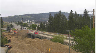
 Never grew out of the phase where you like big trucks and construction equipment? Think the process of tearing down an old bridge an rebuilding it is cool? Well now you
can watch demolition and construction of the new southbound Sullivan Road
Bridge across
 the Spokane River without driving to the site. A link to the construction site webcam has been posted to the City of Spokane Valley's project web page at http://earthcam.net/projects/spokanevalley/sullivanbridge/
Tools on the screen let you get up close to the action by changing camera views, zooming in on sections of each image, or panning from left to right or up and down. Or, watch a time-lapse video of the all the photo images of construction to date. And if you miss a day of watching the webcam, you can use the webcam calendar function to view each of the photo images from a particular day.
Replacement of the bridge, which was built in 1950, has been a priority for the City of Spokane Valley since 2009 when an annual bridge inspection resulted in a rating of "structurally deficient." Weight restrictions were posted in June of 2011, and subsequently removed when temporary repairs were completed in 2012.
The new southbound bridge will be 65 feet wide, with four lanes that will safely accommodate future traffic flow. It will also help relieve congestion at the high-traffic intersection south of the bridge at Sullivan and Indiana.
Also included in the project are a ten-foot-wide multi-use pathway and three river viewing platforms.

No comments:
Post a Comment